
The Voice of the Community Since 1909, Serving Moorcroft and Pine Haven, Wyoming
The Voice of the Community Since 1909, Serving Moorcroft and Pine Haven, Wyoming
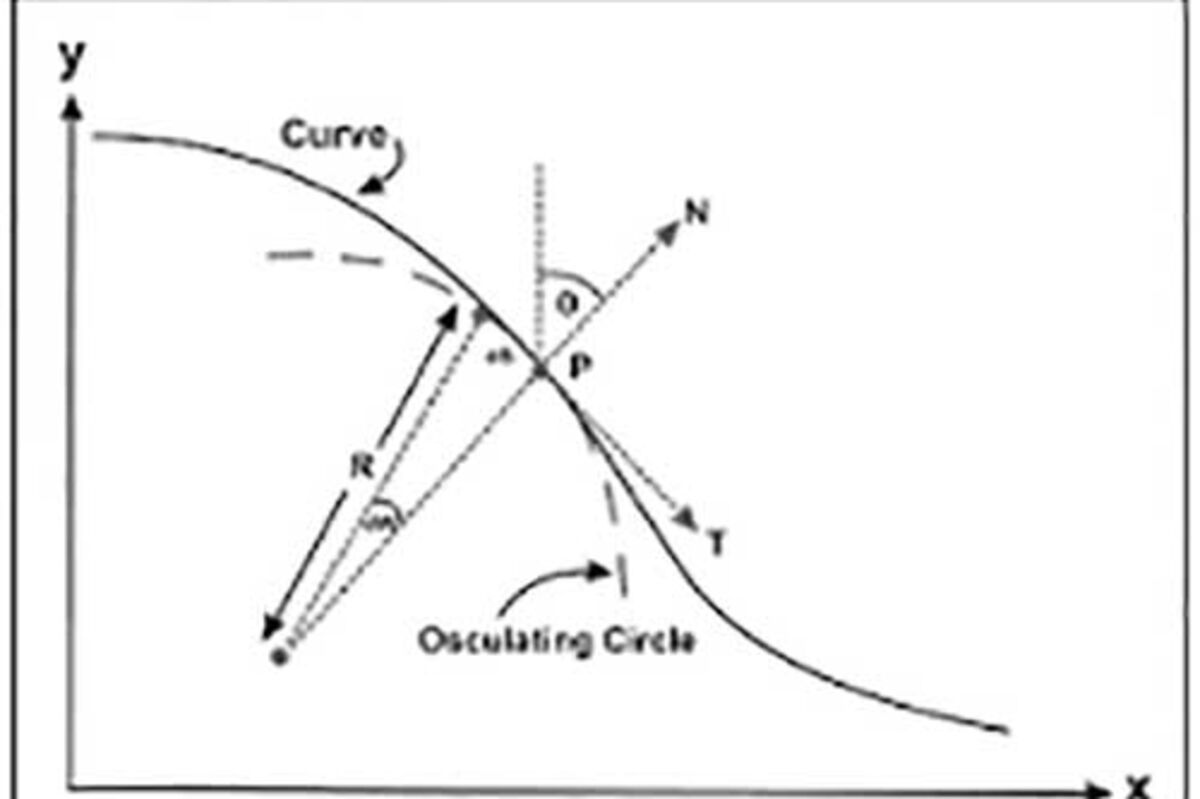
PT (Point of Tangency)
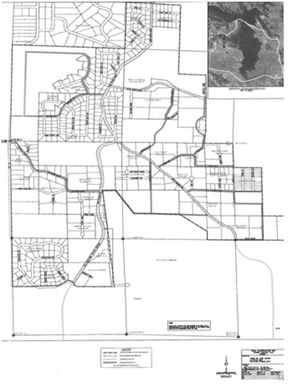
(q) Road Classification Map Street Master Plan
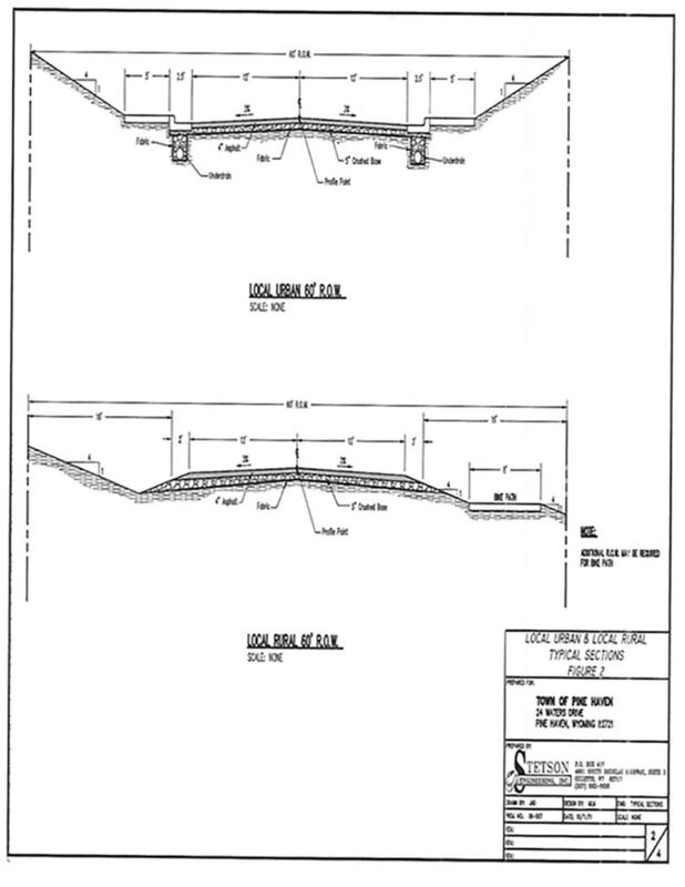
1) Exhibit A Local Urban 60' R.O.W.
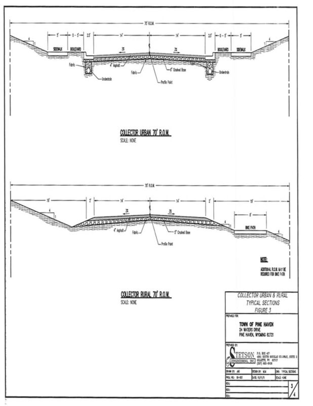
2) Exhibit B Collector Urban 70' R.O.W.
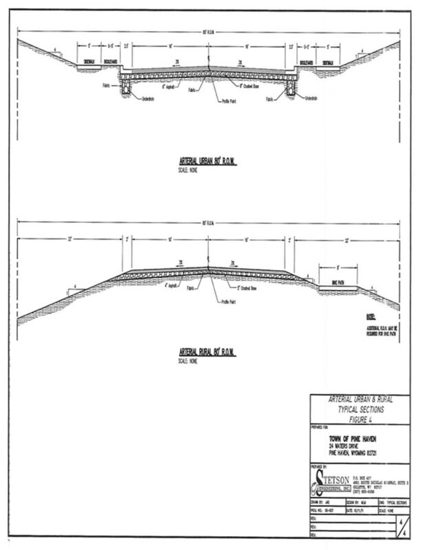
Exhibit C Arterial Urban 80' R.O.W
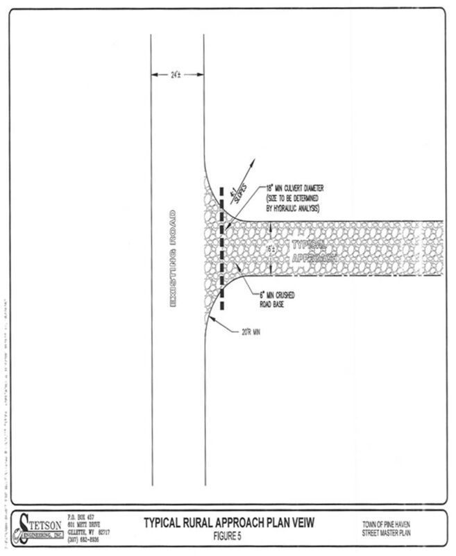
4) Exhibit D Approach
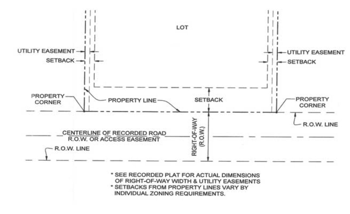
5) Lot Setbacks
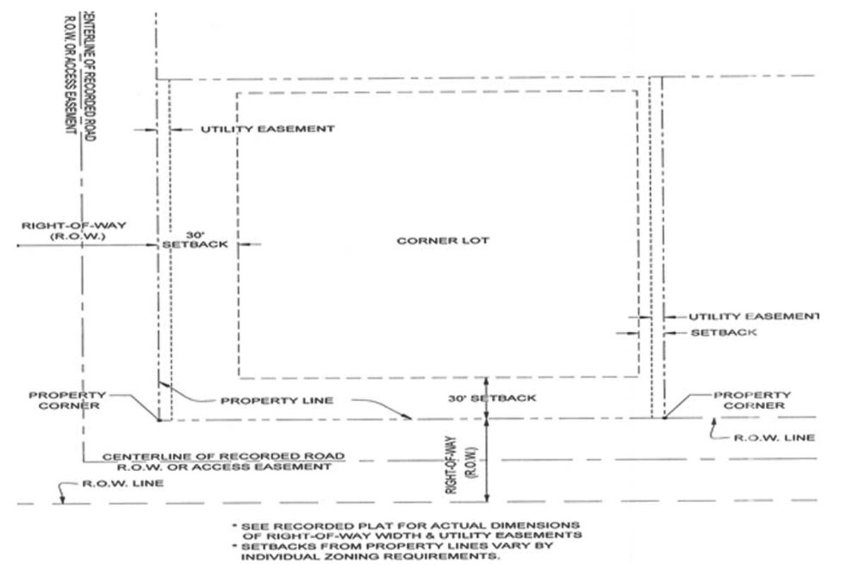
6) Corner Lot Setbacks
Ordinance #1, 2022
AN ORDINANCE AMENDING CHAPTER 24 SUBDIVISIONS IN ITS ENTIRETY, TO THE CODE OF THE TOWN OF PINE HAVEN, WYOMING.
NOW, THEREFORE, BE IT ORDAINED BY THE GOVERNING BODY OF THE TOWN OF PINE HAVEN, CROOK COUNTY, WYOMING, IN REGULAR SESSION DULY ASSEMBLED THAT:
ARTICLE I. - IN GENERAL
Sec. 24-1. - Authority.
This chapter is adopted pursuant to, and in accordance with, the authority vested in the Town, by W.S. 1977,title 15, chapter 1, article 5 (W.S. 1977, § 15-1-501 et seq.) and title 34, chapter 12 (W.S. 1977, § 34-12-101 et seq.).
(Code 2004, ch. 14, art. I, § I(A); Ord. No. 8-2010, 11-23-2010)
Sec. 24-2. - Definitions.
The following words, terms and phrases, when used in this chapter, shall have the meanings ascribed to them in this Section, except where the context clearly indicates a different meaning:
Aggregate Material is a broad category of coarse particulate material used in construction, including sand, gravel, crushed stone, slag, recycled concrete and geosynthetic Aggregates.
All Weather Road Surface – top layer of road is asphalt, concrete, chip & seal and similar types of materials. Gravel is considered an All Weather Road Surface. All roads shall be designed by a licensed Engineer and shall have a minimum of 20 years design lifespan.
Alley means a public Right of way, not less than 16 feet in width, which is not designed for primary travel and is used as a means of access to the rear of residences and Business establishments and affords only secondary means of access to the property abutting along its length.
Annexation has that meaning as prescribed by Wyoming law.
Applicant means a person, firm, corporation, partnership or association, who applies for Subdividing or a variance for any property.
Base Course means the layers placed on the Subbase or subgrade to support the Surface Course.
Bicycle (bike) Path/Multi Use Path means any portion of a Street between the Curb Line and the adjacent property line intended for the use of bicyclists and shall be 8 feet in width and shall meet applicable ADA standards.
Block means a parcel of land entirely surrounded by public highway, Streets, streams, railroad Rights-of-way or parks, etc., or a combination thereof.
Building Permit means authorization by the Building Inspector of the Town to build Structures under the provisions of the building code, or other applicable Town Codes.
Business/Commercial District or Subdivision means a Subdivision which accommodates moderate-impact manufacturing, wholesaling, warehousing and distribution uses, including storage and work-related activities that occur outside of enclosed buildings.
Commission means the Town Planning and Zoning Commission.
Correction Plat means an amendment to an already approved and recorded Plat for the_______correction to any drafting or surveying errors effecting said Subdivision.
Cul-de-sac means a Street having one end open to traffic and being permanently terminated by a vehicle turnaround.
Curb Line means the line between the Right of way for automobiles (road) and the Right of way for pedestrians (Sidewalk).
Dedicated means exclusively assigned or allocated to a particular purpose. Property owners are responsible for any and all permanent changes that interfere with Dedicated Easements or Right of ways.
Drainage Easement means a land area designated on a Plat and set aside to accommodate the calculated and approved flow or storage of stormwaters and kept free of unapproved Structures or other impediments.
Easement means a grant by the property owner to the public, corporation, or persons, to allow the use of land for specific purposes and which takes priority over other uses of that land.
Engineer means a licensed, professional Engineer registered within the state.
Final Plat is the legal document that is recorded with the County Clerk's Office. The primary purpose of the Final Plat is to delineate property boundaries and to describe any Dedicated Rights-of-Way and Easements. The Final Plat shall cover the area which is designated for transfer or sale of Lots.
Improvements refers to installed physical features such as pavements, curbs, gutters, Sidewalks, water mains, sanitary sewers, storm sewers, grading, Street signs, Structures, landscaping and other items for the welfare of the property owners and the general public.
Lot means a defined and numbered parcel of land intended as a unit for transfer of ownership or for development.
Mobile Home Court means a division of a Lot, Tract, parcel or other unit of land into two or more Lots, plots, units, sites or other Subdivisions of land for the immediate or future purpose of sale and placement of mobile homes.
Mobile home park means a parcel (or contiguous parcels) of land which have been planned or used for the placement of two or more rental mobile home Lots utilized for living purposes. Mobile home parks must conform to the provisions of the mobile home park requirements as set by the Town Planning and Zoning Commission and Town Council.
Monument reference point marked by a permanently fixed marker (a survey Monument or marker).
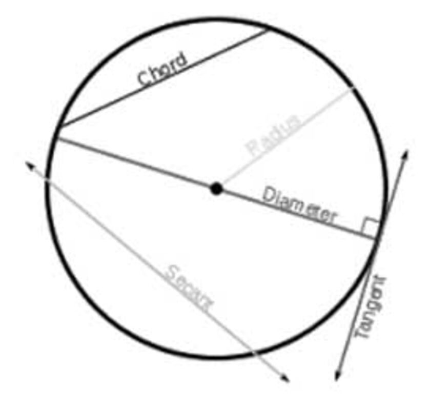
PC (Point of Curvature) means the point where the alignment changes from a straight line or tangent to a circular curve; i.e., the point where the curve leaves the first tangent.
PT (Point of Tangency The point where the tangent touches the curve is the Point of Tangency. Lines or segments can create a Point of Tangency with a circle or a curve. Two circles can also have a common Point of Tangency if they touch, but do not intersect.
Plat means a map or drawing prepared in accordance with the adopted Subdivision regulations and showing the Subdivider's plan for the Subdivision.
Preliminary Plat means a neat and approximate drawing of the proposed Subdivision showing the general layout of Streets, Blocks, Lots and other elements of a Subdivision consistent with the requirements of this Town Code and which shall be the basis for the approval or disapproval of the general layout of the Subdivision.
Resubdivision means an amendment modifying any Lots or Tracts to an already approved and recorded Plat, except for the correction to any drafting or surveying errors.
Right-of-way (R.O.W.) means the area between two property lines, which has been Dedicated for public use for Streets, Alleys, railroads, etc.
Roadbed means the graded portion of a roadway within the top and side slopes prepared as a foundation for the pavement Structure.
Roundabout AKA/Traffic Circle is a type of circular intersection or junction in which road traffic is permitted to flow in one direction around a central island.
Setback means the distance required to comply with the front, side and rear area of a Lot for the open space provisions set forth in one or more Sections 30-70, 30-71, 30-72 and/or 30-73 pertaining to zoning regulations.
Sidewalk means any portion of a Street between the Curb Line and the adjacent property line intended for the use of pedestrians and shall be 5 feet in width and shall meet applicable ADA standards.
Street, Arterial, means a Street of considerable continuity and traffic carrying capacity connecting the various parts of the Town.
Street, Local Residential, means a Street which affords Primary access to abutting, private residential properties.
Street, Primary Collector, means a Public Street, which collects traffic from Local Streets and carried to a major Street or highway.
Structure means anything constructed or erected, the use of which requires a more or less permanent location on the ground. Signs, utility poles and lines, Monuments, statuary, flagpoles, roadways and bridges shall not be considered Structures for the purpose of this chapter.
Subbase means the layers placed on the Roadbed to support the Base Course.
Subdivider means a person, firm, corporation, partnership or association, who causes land to be divided into a Subdivision for himself or others. A Subdivider may also be referred to herein as a Developer.
Subdivision means the division of a Tract of land into two or more Lots or parcels for the purpose of transfer of ownership or building development, or, if a new Street is involved, any division of a parcel of land. The term "Subdivision" includes Resubdivision and the term "Resubdivision" as used herein, shall include any further Subdivision of a Lot or parcel of land previously Subdivided, for sale, use or other purposes, which varies from the latest, approved Subdivision of the same. The term "Subdivide," or any derivative thereof, shall have reference to the term "Subdivision", including Mobile Home Courts or parks, the creation of which constitutes a Subdivision of land.
Layers in the construction of a mortarless pavement: A.) Natural ground B.) Subgrade (Compacted and Moisture conditioned soil) C.) Base Course D.) Pavement/Surfacing
Subgrade Coarse means the native material underneath a constructed road, pavement, or railway track. It is also called formation level.
Surface Course means the upper most layers designed to resist skidding, traffic, abrasion, and weathering.
Surveyor means a licensed, professional Surveyor registered within the state.
Tract means a parcel of land, intended as a unit for transfer of ownership or for development, that has never been Subdivided.
Unsubdivided Property means any property which has not undergone legal Subdivision in accordance with the Town Code and shall include, but not be limited to, all State lands, Federal lands, Unsubdivided ranch lands and any other Unsubdivided lands whether within or outside of the boundaries of the Town.
(Code 2004, ch. 14, art. I, § I(G); Ord. No. 8-2010, 11-23-2010)
Sec. 24-3. - Purpose.
This chapter is adopted for the purpose of promoting the health, safety and general welfare of the Town by preparing regulations designed to:
(1) Regulate traffic flow.
(2) Provide safety from fire, panic and other dangers.
(3) Allow for growth without overcrowding.
(4) Provide adequate water, sewer, parks, transportation and other public facilities.
(Code 2004, ch. 14, art. I, § I(B); Ord. No. 8-2010, 11-23-2010)
Sec. 24-4. - Scope and compliance.
(a) This Town Code shall apply to all of the lands within the boundaries and jurisdiction of the Town as they shall, from time to time, be amended.
(b) Subdivisions shall comply with this Town Code and land use recommendations of the Town Planning and Zoning Commission.
(c) Every owner or proprietor of any Tract or parcel of land who shall hereafter Subdivide or Resubdivide his land into two or more parts shall submit a Subdivision Plat and other Plats in accordance with this Town Code.
(d) The provisions of this Town Code shall not be construed to require replatting whenever Subdivision Plats have been made and legally recorded, pursuant to any Town Codes previously in force.
(Code 2004, ch. 14, art. I, § I(C); Ord. No. 8-2010, 11-23-2010)
Sec. 24-5. - Exemptions.
The provisions of this chapter shall not apply to:
(1) The Subdivision of land for and the sale of cemetery Lots.
(2) The sale of land to the state or any political Subdivision thereof.
(3) Any designated Lot or any already recorded Subdivision, if the Lot is not being altered in any way.
(Code 2004, ch. 14, art. I, § I(D), (E)(2); Ord. No. 8-2010, 11-23-2010)
Sec. 24-6. - False statements and Violations.
(a) Any person with knowledge of, or any person who knowingly authorizes, directs or aids in the publication, advertisement, distribution or circulation of any false statement or misrepresentation concerning any Subdivision Lot in the Town, may be guilty of a violation of this Code.
(b) Any person who violates any provision of this Town Code and any person who, as an agent for a Subdivider, developer or owner of Subdivided lands, offers for sale any Subdivided lands or Subdivisions without first complying with the provisions of this Town Code may be guilty of a violation of this Town Code.
(Code 2004, ch. 14, art. I, § I(E)(1); Ord. No. 8-2010, 11-23-2010)
Secs. 24-7-24-30. - Reserved.
ARTICLE II. - DESIGN STANDARDS
Sec. 24-31. - General standards.
(a) The design and development of a Subdivision shall preserve, insofar as it is possible, the natural terrain, natural drainage, existing topsoil and trees.
(b) In designing the Subdivision, the Subdivider shall consider the topography and its influence on Street patterns with a minimum of two entrances to the Subdivision, and the separation of pedestrian activities from vehicular activities.
(c) Permanent Easements are required for utility service and, except for Subdivisions of land which border Unsubdivided property, shall be provided ten feet in width on each side of the appropriate Lot lines, for a total minimum Easement width of 20 feet. Any proposed Lot which borders Unsubdivided property shall provide for permanent Easements of 20 feet in width on each side of the Lot which borders the Unsubdivided property.
(d) The Street plan and profile shall be submitted at the same time as the Preliminary Plat to the Planning and Zoning Commission and shall have six full size (24 inches by 36 inches) copies of the Plat showing the following information:
(1) Horizontal.
a. Prepared at a maximum scale of one inch equals 50 feet with north arrow.
b. Street lights, Sidewalks, Bicycle Paths, etc., for pedestrian activities.
c. Drainage crossings and size of culvert.
d. Typical cross section.
e. Property and Lot lines within 100 feet of the Right-of-way.
(2) Vertical.
a. Prepared at a minimum scale of one inch equals five feet.
b. Location of all Points of a Curvature (PCs) and Points of Tangency (PTs) with the elevation.
c. Percent of slope on all tangents.
d. Drainage crossings and size of culvert.
(e) The utility plan and profile shall be submitted at the same time as the Preliminary Plat to the Planning and Zoning Commission and shall have six full size (24 inch by 36 inch) copies of the Plat showing the locations and size of sewer mains, water mains and fire hydrants within the proposed Subdivision, and immediately adjacent thereto.
(f) The drainage plan designed by a professional Engineer licensed by the state, shall be submitted at the same time as the Preliminary Plat to the Planning and Zoning Commission and shall have six full size (24 inch by 36 inch) copies of the Plat showing existing contours at an interval of five feet along with the locations and size of Drainage Easements and drainage detention areas, clearly labeled as such, within the proposed Subdivision and immediately adjacent thereto.
(Code 2004, ch. 14, art. III, § I; Ord. No. 8-2010, 11-23-2010)
Sec. 24-32. - Topography and drainage.
(a) Land subject to flooding shall be reserved for uses which do not increase the danger of flooding or are not endangered by flooding, which might occur, or they shall be set aside in a designated Drainage Easement. Subdivisions which include floodplains or designated Drainage Easements within their boundaries shall be Platted in such a way that the proposed buildable area for habitable Structures is outside of the Easement or area subject to flooding.
(b) No Drainage Easement shall be allowed on residential side Lot lines, unless drainage Improvements are placed underground.
(c) All Street drainage crossings shall be provided with a drainage Structure of adequate capacity, but in no case less than 18 inches in diameter with a smooth noncorrugated interior surface and flared ends. The following return period, in years, shall be used for drainage design:
Minor Storm Major Storm
Residential, parks, cemeteries, open public land 2 100
Commerical/office/Business 5 100
Industrial 10 100
Where there are multiple zoning designations that apply within the same drainage area, the greater design storm shall govern. All drainage Improvements shall be designed to convey the minor storm as a minimum. Minor facility Improvements may need to be designed to carry some part or all of the major storm flows if major storm flows cannot be conveyed safely to a suitable receiving system, or if allowable flow depths in Streets cannot be maintained. In addition, consideration should be given to the impact of storms greater than the major storm to anticipate and reduce the potential for significant flood damage.
(d) Lands subject to other natural hazards shall be identified and shall not be Subdivided until the hazards have been eliminated or until adequate plans have been submitted and approved for eliminating or neutralizing the hazard.
(Code 2004, ch. 14, art. III, § II; Ord. No. 8-2010, 11-23-2010)
Sec. 24-33. - Streets, roads and Alleys.
(a) All Streets and roads within the proposed Subdivision shall be designed in accordance with the applicable criteria and specifications as provided in the AASHTO (American Association of State Highway and Transportation Officials) publication "A Policy on Geometric Design of Highways and Streets," current edition (or latest non-metric edition plus applicable technical corrections) and that meets ADA standards (American Disability Act,) or other applicable nationally recognized standards for pavement and Sidewalks.
(b) The Street/Road Section shall meet the minimum standards set forth in the Street master plan, or by a geotechnical Engineer, licensed to practice in the state, based on traffic counts and soil bearing capacities of the proposed road.
(c) The name of all Streets shall not duplicate or closely resemble the names of any Street previously filed in the county.
(d) The arrangement of roads and Streets shall conform to the duly adopted Street plan of the Town, as it shall from time to time be determined.
(e) Dead end Streets are prohibited, except where they may be necessary to provide future access to adjacent undeveloped property.
(f) Cul-de-sacs shall not be longer than 500 feet to the center of the bulb. The bulb shall have an edge of roadway surface radius of not less than 50 feet and a Right-of-way radius of not less than 85 feet. For alternative emergency service access, Streets which cannot be served by a maximum length Cul-de-sac should have a minimum of two accesses to a publicly maintained road.
(g) Streets that are obviously in alignment with existing, Platted and named Streets shall bear the name of the existing Street.
(h) Whenever a Dedicated or Platted half-Street or Alley exist, adjacent to the Tract to be Subdivided, the other half of the Street or Alley shall be Dedicated as a public way.
(i) Local Residential Streets shall be planned to discourage through or non-local traffic within the Subdivision.
(j) Under normal conditions Streets shall be laid out to intersect as nearly as possible, at right angles. Where topography or other conditions justify a variation, the variation from the right angle shall be no more than 30 degrees.
(k) If a Streets jogs at an intersecting Street and does not continue in a straight alignment, the centerline offset of the two parts of the Street approaching the intersecting Street shall be not less than 150 feet.
(l) No more than two Streets shall intersect at one point.
(m) Alleys shall be provided in Commercial and Industrial Districts, unless definite provisions are made for service access.
(n) Where a residential Subdivision abuts a major highway, a frontage road may be required.
(o) Roundabouts shall not be permitted.
(p) The Right-of-way and surface widths for roads, Streets and Alleys included in any Subdivision shall not be less than the minimum dimensions for each classification, as shown below:
Classification Pavement Width (feet) Right-of-Way Width (feet)
Alley 16 20
Local 24 60
Collector 28 70
Arterial Streets 32 80
(q) Road Classification Map Street Master Plan
(r) Typical cross sections:
1) Exhibit A Local Urban 60' R.O.W.
2) Exhibit B Collector Urban 70' R.O.W.
Exhibit C Arterial Urban 80' R.O.W
4) Exhibit D Approach
5) Lot Setbacks
6) Corner Lot Setbacks
(s) When existing or anticipated traffic on Arterial or Collector thoroughfares warrants greater widths of Right-of-way, the additional width shall be provided as determined by the Town's Planning and Zoning Commission.
(t) Any Commercial section of any Subdivision application will adhere to Collector Street design specifications.
(u) All changes in Street grades shall be connected with vertical curves and all changes in Street alignment shall be connected with horizontal curves. All curves will be designed according to well established criteria found in standard engineering texts.
(v) Unless design conditions require larger radii, the minimum centerline radius shall be:
(1) Primary Collector Streets: 750 feet.
(2) Local Residential Streets: 300 feet.
(w) A tangent of at least 100 feet shall be provided between all reverse curves.
(x) All Street grades shall be more than one-half of one percent and less than ten percent for all Streets. Deviation from these standards will require approval from the Town's Planning and Zoning Commission
(y) The Town reserves the right to include or deny Curb and gutter drainage within a Subdivision design.
(z) Any Alley designated or required by the Planning and Zoning Commission will be constructed to the same Street standards within the designated Alley row width.
(Code 2004, ch. 14, art. III, § III; Ord. No. 8-2010, 11-23-2010)
Sec. 24-34. - Water.
Where the Town's water system is proposed as a domestic water source, design plans shall be provided as part of the Preliminary Plat submittal by the Subdivider and the Subdivider's Engineer and shall demonstrate the availability of an adequate supply of potable water and an appropriate system of conveyance in accordance with DEQ and other state regulations. Final Subdivision approval shall not be granted prior to the issuance of a permit to construct from DEQ.
(Code 2004, ch. 14, art. III, § IV; Ord. No. 8-2010, 11-23-2010)
Sec. 24-35. - Sewer.
(a) Where the Town's sewer system is proposed as a domestic sewer system, design plans shall be provided as part of the Preliminary Plat submittal by the Subdivider and the Subdivider's Engineer and shall demonstrate the availability of an adequate system of disposal in accordance with DEQ and other state regulations. Final Subdivision approval shall not be granted prior to the issuance of a permit to construct from DEQ.
(Code 2004, ch. 14, art. III, § V; Ord. No. 8-2010, 11-23-2010)
Sec. 24-36. - Electrical.
Street lights may be required by the Town. If Street lights are installed, they shall be installed at the sole cost of the developer. All future maintenance of any installed Street lights shall be the responsibility of the landowners within the Subdivision or utility company that assumes such responsibility after installation of the Street lights.
(Code 2004, ch. 14, art. III, § VI; Ord. No. 8-2010, 11-23-2010)
Sec. 24-37. - Tracts, Blocks and Lots.
(a) All Blocks and all Lots within each Block shall be consecutively numbered. Numbering of Blocks and Lots in later phases of a phased Subdivision shall continue the sequence established in earlier phases.
(b) A Tract is a land area, usually larger in size than a typical Lot, set aside for a special use or not otherwise included within the normal Subdivision pattern of Blocks and Lots. Tracts shall bear a letter designation, such as Tract A. Letter designation of Tracts shall be sequential and shall not duplicate designations of Tracts in earlier phases of a phased Subdivision.
(c) Blocks in residential Subdivisions shall be not less than 500 feet wide and not more than 1,200 feet long, except as expressly allowed by the Planning and Zoning Commission and the Town Council.
(d) In a residential development, the Block width shall normally be sufficient to allow two tiers of Lots. Blocks for Business or Industrial use shall be of suitable width and depth.
(e) Every Platted Lot shall abut on a Street other than an Alley.
(f) Side Lot line shall be approximately at right angles to straight Street lines or radial to curved Street lines.
(g) Whenever Lots are Resubdivided, the newly created Lots shall be numbered to avoid duplication of any original Lot numbers, for example Lots 2 and 2A.
(h)Any and all Business/Commercial or Commercial Zoned property within all Subdivisions will adhere to Collector Street design specifications.
(Code 2004, ch. 14, art. III, § VII; Ord. No. 8-2010, 11-23-2010)
Secs. 24-38-24-58. - Reserved.
ARTICLE III. - CONSTRUCTION STANDARDS
Sec. 24-59. - General standards.
(a) Construction of Subdivision Improvements shall not commence without a permit to construct issued by the Town Council designate or his representative.
(b) Additional requirements for the performance of work are contained in the current edition of the Wyoming Public Works Standard Specifications. No construction shall start until the Subdivider has submitted and the Council has approved the following:
(1) A Subdivision agreement to construct any required Public Improvements shown in the Final Plat documents. A Subdivider shall provide security in the name of the Town of Pine Haven of a sufficient amount to complete the project in accordance with design and time specification. The agreement shall authorize the time for the completion of Public Improvements up to a maximum of 18 months. Other agreements or contracts setting forth the plan, method, and parties responsible for the construction of any required Public Improvements shown in the Final Plat documents which, in the judgment of the Council, will make reasonable provision for the completion of the Improvements in accordance with design and time specifications.
(2) As Improvements are completed, the Subdivider may apply to Council for a release of part of the security deposited with Council. Upon inspection and approval, the Subdivider shall warrant the Improvements for two (2) years and Town Council may release the security. The warranty period shall commence when all applicable Improvements are completed in a phase and accepted as complete. If the Town Council determines that the Subdivider will not construct the Improvements in accordance with the specifications, the Town Council shall have 14 days from the date of all applications to make a determination. An additional 14 days may be granted if declared necessary by Council. If the Town Council determines that any Improvements are not constructed in substantial compliance with specification, it shall furnish the Subdivider a list of specific deficiencies and shall be entitled to withhold security sufficient to ensure such substantial compliance
(3) The design and construction of the following Public Improvements within a Subdivision shall generally be performed in accordance with the requirements listed herein:
a. Road grading and surfacing.
b. Streetlights.
1. Street lighting capable of illumination of Streets and pedestrian walkways for safe movement of vehicles and pedestrians at night may be required.
2. The design of the Street lighting system shall be prepared by the Subdivider's Engineer and shall be subject to approval by the Town Council.
c. Sidewalks.
1. If Sidewalks are installed, they shall be constructed of concrete and shall be 5 feet in width and shall meet applicable ADA standards.
2. Sidewalks on major Streets shall be constructed adjacent to the property line on land Dedicated to public use.
d. Sanitary sewer system as required by this Town Code.
e. Potable water system as required by this Town Code.
f. Storm sewers or storm drainage system, as required.
g. Permanent reference Monuments and Monument boxes.
h. Underground telephone, electrical, and other utility lines.
i. Other facilities as may be specified or required in this chapter by the Town Planning and Zoning Commission or Town Council.
j. Mail receptacles with specifications meeting U.S. Postal Service requirements. The Town may require centralized mail receptacles be installed at the Developer's expense.
(4) Upon completion and acceptance of all remaining Public Improvements within a Subdivision or phased portion of a Subdivision, a warranty shall be executed on behalf of the developer guaranteeing the Public Improvements for two years from the date of final approval established by Town Council. The warranty form shall be provided to the Town Council.
(c) During the construction of Subdivision Improvements, the Subdivider shall retain an Engineer with full responsibility for the inspection of construction. The Town Engineer or his representative will make periodic inspections of the project. If work is not being performed in conformance with approved plans and specifications, the Town may issue an order to correct portions of the work. A properly issued order to stop work shall not release the Subdivider from the terms of the contract.
(d) Monuments shall be placed at the corners of all Tracts, Blocks and Lots and at Subdivision boundary corners. Monuments at major Subdivision boundary corners shall be a two inch diameter aluminum cap; this requirement follows the state board of registration for professional Engineers and land Surveyors. All Tract, Block and Lot corners shall be #5 rebar, a minimum of 18 inches long, with aluminum caps. All Monuments must be stamped with the licensed land Surveyor's number, and the top is to be flush with the ground.
(e) Prior to the approval of the completed Improvements, as-built plans must be submitted to the Town Council. The plans shall be submitted on 24 inch by 36 inch Mylar, electronically in PDF format, and accompanied by two sets of prints. The plan submittal shall contain:
(1) A cover sheet.
(2) The Subdivision Plat.
(3) The overall Street layout.
(4) The overall water system.
(5) The overall sanitary sewer or septic system.
(6) The overall drainage plan.
(7) As-built GPS shots on manholes, valves, hydrants and water surfaces on Town survey control.
(8) Additional detail sheets, as necessary, at one inch equals 50 feet scale, with title Block and sheet numbers in the lower, right-hand corner of each page, and showing the detailed location of all utilities to include service lines to Lots. A permanent benchmark shall be described on each sheet.
(f) The following certification by the project Engineer shall appear on the face of the plans:
I certify that these plans were prepared under my direct supervision and control, that they accurately represent the referred to Improvements as they have been constructed in the field, and that the Improvements, as installed, conform to the requirements of the Town Engineer and other applicable agencies. ____________ Engineer Wyoming P. E. Number
(Code 2004, ch. 14, art. IV, § I; Ord. No. 8-2010, 11-23-2010
Sec. 24-60. - Roads, Streets and Alleys.
(a) Streets shall be surfaced with materials approved by the Town Council and according to provisions of Section 24-33.
(b) Prior to acceptance of any road system, the developer shall provide results of core tests or other acceptable tests, as may be determined by the Town Council from time to time, to verify minimum thickness as previously set forth by the geotechnical engineer for the developer. Tests shall be taken a minimum of once per 500 lineal feet of roadway. The developer shall also provide compaction test results for review. Subgrade compaction tests shall be required for every one-foot layer of backfill at lineal intervals not to exceed 200 feet. Compaction tests on gravel surfaces shall also be required at intervals not to exceed 200 feet. Moisture content of material at the time of compaction shall be provided for base and subbase as required by the current edition of the Wyoming Public Works Standard Specifications.
(c) Any and all road systems may be approved and accepted only after meeting the required standards and becoming 100 percent complete in accordance with this provision.
(d) After a Town Street has been surface coated with concrete, asphalt, chip seal or magnesium chloride, any utility installation or repair has to be bored and cased, if necessary, under the Street. Any and all repairs will be made to present Town standards.
(e) Utility crossings of roads not yet brought up to standards will be replaced as per the requirements of this Section.
(f) Prior to acceptance of any road system it must be totally complete and meet the required standards.
(g) The town retains the right to reject any road system if not completed to Town standards. If the roads are rejected and not corrected to town standards, or if insufficient bonding exists for the Town to correct the roads, the subdivision homeowners, the developer or the businesses that are in the subdivision will maintain the roads. The developer shall notify any purchaser of a lot or tract that the roads are not constructed to standards and they will be responsible for the maintenance required. In such event, the developer shall establish a governing body for the subdivision which shall have authority to assess the owners within the subdivision for maintenance and repairs of the roads.
Sec. 24-61. - Water.
(a) The Town public water supply system shall be used by the Subdivision and shall be installed in proper Easements or within the limits of the Street and Alley Right-of-way and shall be of a size as approved by the Town.
(b) Standards for a water supply system shall be in accordance with the requirements of the Town.
(c) No dead-end mains shall be allowed.
(Code 2004, ch. 14, art. IV, § III; Ord. No. 8-2010, 11-23-2010)
Sec. 24-62. - Sewer.
(a) The Town public sewer system shall be used by the Subdivision and shall be installed in such a manner that it will provide service to each Lot within the Subdivision. The system of lateral sewers shall collect the sewage within the Subdivision and discharge it into the Town's main sewer disposal system.
(b) Standards for a sewer system shall be in accordance with the requirements of the Town.
(Code 2004, ch. 14, art. IV, § IV; Ord. No. 8-2010, 11-23-2010)
Sec. 24-63. - Electrical.
Electrical distribution, trenching, conduit and transformer pads shall be installed as required.
Secs. 24-65-24-85. - Reserved.
Sec. 24-64. - Other Improvements.
(a) If other Improvements are required, such as tree planting, retaining walls, drainage Structures, etc., such Improvements shall be made in accordance with the recommendations of the Planning and Zoning Commission.
(b) At any time after the completion of construction of public Streets and their inspection by the Town Engineer, the Subdivider may request that the Town accept maintenance of the Streets. The developer shall provide a two-year warranty on the construction from the time of the acceptance by the Town.
(c) The Subdivider shall have the obligations for the following Improvements:
(1) Monuments.
(2) Grading, drainage and drainage Structures.
(3) Road Improvements.
(4) Water mains and fire hydrants.
(5) Water distribution lines.
(6) Sanitary sewer mains and laterals.
(7) Electrical distribution, as required.
(8) Other facilities deemed necessary by the Town Council.
(Code 2004, ch. 14, art. IV, § V; Ord. No. 8-2010, 11-23-2010)
ARTICLE IV. - PROCEDURES AND REQUIREMENTS
Sec. 24-86. - Submitting Plats.
(a) Preapplication. The Subdivider shall request that the Planning and Zoning Commission review and comment on a sketch Plat prior to his preparation of a Preliminary Plat. The purpose of this preapplication procedure is to determine any problems with the proposed development before expenses are incurred in the preparation of the Preliminary Plats. The following items will be reviewed by the Commission and are not inclusive:
(1) The procedures and requirements for filing all required Plats.
(2) Availability of public water and sewer and requirements when public systems are not readily available.
(3) Zoning and building Setback requirements on the property.
(4) Requirements for the design and construction of Improvements for the Subdivision.
(5) Dedication of public land used for parks, playgrounds or open space.
(6) Amount of fees that are required.
(7) A design report showing impact on the community and surrounding area. This report is to be supplied by the Subdivider's project Engineer. Items to be considered, but not inclusive, are water, sewer, roads, drainage, economic development, socioeconomics and emergency services.
(b) Submittal of Preliminary Plats.
(1) The Preliminary Plats shall be submitted 14 days or more prior to the Planning and Zoning Commission meeting and shall have six full size (24 inch by 36 inch) copies of the Subdivision Plat, Street plan and profile, utility plan and profile and the drainage Plat showing all the information that is required on the Final Plats to the Town's Planning and Zoning Commission.
(2) The Preliminary Plat shall be accompanied by a remittance of the total fees as required by Section 24-113(a) and Section 24-112, if fees in lieu of dedication of public land are to be paid.
(3) The following information and material shall also be required as part of any Preliminary or Final Plat submittal and shall accompany the Preliminary Plat:
a. The names, addresses and phone numbers of the developer or Subdivider, and the individual or firm responsible for the preparation of the Plats.
b. The names and addresses of all the owners of Subdivided land and Unplatted land contiguous and within 250 feet adjacent to the boundary of the proposed Subdivision.
c. Number and size of proposed Lots.
d. Land use in the proposed Subdivision and immediately adjacent areas.
e. A drainage report, over-Lot grading plan and design drawings of drainage facilities will be part of the Subdivision application procedure. The report shall show any impact to adjacent property.
g. A statement explaining how and when the Subdivider proposes to install water, sewer, Street and other required Improvements and indicating the manner in which storm drainage and detention is to be accomplished within the Subdivision.
h. Engineer Shapefile (preferred file) - street plan and profile, utility plan and profile and the drainage Plat of the Subdivision shall be submitted.
(4) The following information and material shall be required as part of any Preliminary and Final Plat submittal and shall accompany the Preliminary Plat:
a. A proposed Subdivider shall petition the Town for Annexation regardless of an application for appropriate Town Zoning for the Subdivided area, if the existing zoning District does not allow the type of use proposed or if the area is to be annexed.
b. A petition for Annexation shall be submitted to the Town, if the land to be Subdivided is contiguous by itself or as part of a larger Tract to the boundaries of the Town.
c. A statement describing the development and maintenance responsibility for any Streets, ways or open spaces; provided, however, that the final determination as to requiring open spaces or allowing a fee in lieu shall rest solely with the Town.
d. The location of the proposed property required for the dedication of public land used for parks, playgrounds or open space or a statement describing the calculations used for the dollar amount of the fees in lieu thereof as described in Section 24-112.
e. No private roads or gated Communities will be allowed in the Town
f. A description of the phasing and scheduling of phases for the development if the Final Plat is to be submitted in separate phases.
g. Location, dimension, and size in acres of all sites proposed to be used for residential, multifamily, Commercial, Industrial, and open space with the use noted.
h. The recommendation of a qualified Engineer regarding soil suitability, erosion control, sedimentation and flooding problems shall be used.
(5) After receipt of the Preliminary Plat and all required supporting materials the Planning and Zoning Commission shall schedule the Plat for their next regular meeting which occurs 14 days or more after the date on which the Plat was submitted, (31 days when a Preliminary Plat is submitted in conjunction with a rezoning application), and shall within three days, transmit copies to appropriate agencies and officials for their review and comment. At a minimum, copies of the Plat shall be referred to:
a. The Planning and Zoning Commission.
b. The Town's Street Committee and/or Administrator.
c. The Town's Utility or Special Districts Committee and/or Administrator.
d. The Town's Fire Department.
e. The Town Council.
(6) Agencies receiving referral copies of the Preliminary Plat should present comments on the Plat before the Planning and Zoning Commission meeting at which the Plat is considered.
(7) Not less than 15 days or when in conjunction with a rezoning or variance request as required in Chapter 30 Zoning Regulations for public hearings, prior to the date of the Planning and Zoning Commission meeting at which the Plat is to be considered, the Planning and Zoning Commission shall, from information provided by the Subdivider as a part of his Preliminary Plat submittal, notify the owners of the Subdivided Lots and owners of Unplatted land contiguous and within 250 feet adjacent to the boundaries of the proposed Subdivision of the time and date of the meeting.
(8) The Subdivider and all other interested or affected parties shall be allowed to offer comments on the Preliminary Plat at the Planning and Zoning Commission meeting. After due deliberation the Planning and Zoning Commission shall communicate its findings and recommendations to the Town Council in writing, who shall then either approve or disapprove the Preliminary Plat and notify the Subdivider in writing within ten days after the date of the Council meeting at which final action is taken. The Planning and Zoning Commission may attach conditions to its recommended approval. If Planning and Zoning recommends the Plat not be approved, the Planning and Zoning Commission shall recommend conditions under which the Plat may gain approval.
(9) If the Subdivider challenges the conditions of approval attached by the Planning and Zoning Commission are of such nature as to make development of his land impractical, or if the Subdivider contends that disapproval of his Preliminary Plat by the Planning and Zoning Commission was a wrongful decision he may, in writing, request a hearing before the Town Council and proceed according to the provisions of Section 24-137 Appeals.
(10) The approval of the Preliminary Plat does not constitute an acceptance of the Subdivision, but is deemed to be an authorization to proceed with the preparation of the Final Plat. The approval of the Preliminary Plat shall only be effective for a period of six months, unless an extension is granted by the Planning and Zoning Commission.
(11) If a Final Plat has not been submitted for approval within six months of the approval of the Preliminary Plat by the Town Council, a Preliminary Plat must be submitted again to the Planning and Zoning Commission for approval.
(c) Submittal of Final Plats.
(1) When the Plat is submitted it shall be accompanied by the total amount of the Final Plat fees as required in Section 24-113(b) Fees.
(2) The Final Plat and required supporting material shall conform to the design and Engineering standards of the state, this Town Code and to any condition of approval specified by the Planning and Zoning Commission and Town Council shall be submitted 14 days or more prior to the Planning and Zoning Commission meeting.
(3) The Final Plat of the Subdivision shall be submitted in six full size (24 inch by 36 inch) copies and one reproducible copy (Mylar) to be filed in the office of the clerk and recorder in the county by the Town, showing all the information that was required on the Preliminary Plat with the corrections and additions as requested by the Planning and Zoning Commission and Town Council.
(4) The Street plan and profile, utility plan and profile and the drainage Plat of the Subdivision shall be submitted in six full size (24 inch by 36 inch) copies showing all the information that was required on the Preliminary Plats with the corrections and additions as requested by the Planning and Zoning Commission and Town Council. Engineer Shapefile (preferred file) - street plan and profile, utility plan and profile and the drainage Plat of the Subdivision shall be submitted.
(5) Any updated information and material that was required to be submitted as part of the Preliminary Plat submittal shall accompany the Final Plat.
(6) No Final Plat shall be recorded until the Subdivider has a Subdivision agreement to construct any required Public Improvements shown in the Final Plat documents. The Subdivider shall provide security in the name of the Town of Pine Haven of a sufficient amount to complete the project in accordance with design and time specification. The agreement shall authorize the time for the completion of Public Improvements up to a maximum of 18 months.
(7) The submitted Final Plat shall contain the notarized signatures of the owner or owners, mortgages or others with an equitable interest in the land and the signatures of the registered land Surveyor and Engineer.
(8) After receipt of the Final Plat and all supporting materials, and within three days, transmit copies to the appropriate agencies and officials for their review, comments and signatures. Copies of the Plat shall be referred to:
a. The Planning and Zoning Commission.
b. The Town's Street Committee and/or Administrator.
c. The Town's Utility or Special Districts Committee and/or Administrator.
d. The Town's Fire Department.
e. The Town Council
(9) Agencies receiving referral copies of the Final Plat should present comments on the Plat at the Planning and Zoning Commission meeting at which the Plat is reviewed for the corrections and additions as requested by the agencies, Planning and Zoning Commission and Town Council.
(10) No Final Plat shall be approved unless it conforms to the regulations of all Town Codes.
(11) Within 45 days after receiving the recommendations of the Planning and Zoning Commission, along with the Final Plat and accompanying materials, the Town Council shall either approve the Final Plat or disapprove the Final Plat and notify the Subdivider of the conditions to be met to gain approval. If a disapproved Final Plat is modified and resubmitted to the Town Council at a later date for their consideration, the Council may require the concurrent submittal of an updated ownership and encumbrance report or title opinion.
(12) Upon approval by the Town Council of the Final Plat, the Town Clerk shall transmit the Subdivider's recording fee and the duly-adopted and executed Final Plat and other documents required by law to the county clerk and recorder for the filing among the official records of the county.
(13) Building Permits shall not be issued until all required Monuments; sewer, water, Street and other required Improvements are installed and approved by the Town's Planning and Zoning Administrator or designated official.
(d) Submittal of corrected Plats. If after the approval and recording of a Final Plat, errors are found in the language or numbers on the recording Plat, the Subdivider shall file a corrected Plat with notations made on the face of the Plat listing all corrections made and the book and page numbers where the original Plat was recorded. The Plat shall be noted "corrected Plat" under the name of the Subdivision. The Plat properly signed, corrected and revised shall be submitted to the Planning and Zoning Commission with six full size (24 inch by 36 inch) copies and one reproducible copy (Mylar). The Planning and Zoning Commission shall review the Plat for corrections, secure the signatures of the proper Town officials on the corrected Plat and present the Plat to the Town Council for their reaffirmation of their approval and to transmit the Subdivider's recording fee and the duly adopted and executed corrected Plat to the county clerk for recording. The recording of the corrected Plat shall void the incorrect Plat, and the county clerk shall note "VOID" across the face of the incorrect Plat.
(e) Submittal of Resubdivision Plats.
(1) If, after the approval and recording of a Final Plat, a property owner wishes to make minor modifications to the location of Lot lines on part or all of a recorded Plat, and there is no change in the location or the size of Dedicated Streets, the property owner shall submit a new Final Plat drawing, with the Lotting arrangement revised. The Planning and Zoning Commission shall first determine whether the proposed changes constitute minor or substantial changes to the Plat. Said determination shall be solely within the discretion of the Planning and Zoning Commission. Provided that the changes are deemed to be minor changes to the Plat, the Planning and Zoning Commission shall then determine which of the required supporting documents shall be resubmitted with the revised Final Plat. The Subdivision shall be identified as the "Resubdivision of" above the name of the Subdivision and shall be processed the same as a Final Plat.
(2) If, after the approval and recording of a Final Plat, a property owner wishes to substantially change the Street and Lotting arrangement of part or all of the Platted area, the resulting Subdivision shall be treated as a new submittal, with both Preliminary and Final Plats required. Based on the currency of the information submitted with the original Plat, the Planning and Zoning Commission shall determine which of the required supporting documents must be resubmitted. The Subdivision shall be identified as the "Resubdivision of" above the name of the Subdivision and shall be processed the same as a Final Plat.
(3) When the Plat of a Subdivision or Resubdivision intends to vacate an existing Easement, the location of the Easement shall be shown on the Plat with a notation that it is being vacated by the Plat.
(f) Submittal of Annexation Plats. Additions to the Town by Subdividing.
(1) The owner of any land within or contiguous to the Town may Subdivide the land into Lots, Blocks, Streets, avenues and Alleys and other grounds under the name of ________addition to the Town. An accurate map or Plat shall be made designating the Subdivided land and particularly describing the Lots, Blocks, Streets, avenues and Alleys and other grounds of the addition. The Lots must be designated by numbers, and the Streets, avenues and other grounds by name or numbers.
(2) All information and material that was required as part of the Preliminary Plat and Final Plat submittal shall accompany the Annexation Plat.
(3) The Plat shall:
a. Be acknowledged before an officer authorized to acknowledge deeds;
b. Have appended a survey made by a land Surveyor registered under the laws of this state with a certificate that he has accurately surveyed the addition, and that the parts thereof are accurately staked off and marked with an appropriate metal Monument including magnetic iron inscribed at least with the registration number of the land Surveyor to provide source identification, at all Lot corners and survey control points of the addition.
(4) When the map or Plat is completed, acknowledged, certified and approved by the Town Council, it shall be filed and recorded in the office of the county clerk. When filed, it is equivalent to a deed in fee simple to the Town from the owner of all Streets, avenues, Alleys, public squares, parks and commons and of that portion of the land set apart for public and Town use. All additions thus laid out are a part of the Town for all purposes, and the inhabitants of the addition are entitled to all the rights and privileges and subject to all the laws, ordinances, rules and regulations of the Town.
(5) The Town Council, by ordinance, may compel the owner of any addition to lay out Streets, avenues and Alleys to correspond in width and direction and be continuations of the Streets, ways and Alleys in the Town or other additions thereto. No addition is valid unless the terms and conditions of this article are complied with and the Plat submitted and approved by the Town Council.
(Code 2004, ch. 14, art. II, § I; Ord. No. 8-2010, 11-23-2010)
Sec. 24-87. - Information required on Subdivision Plats.
All Plats shall include the following information on the face of the Plat:
(1) The following shall be entered at the top center of each sheet. (The name of the Subdivision shall not duplicate or too closely resemble the name of any other Subdivision previously filed in the county.)
PRELIMINARY or FINAL PLAT
(NAME OF THE SUBDIVISION)
IN THE TOWN OF PINE HAVEN, WYOMING
A SUBDIVISION OF THE
(SUBSECTION) OF Section ____________, T. ____________ N, R. 66W, of the
Sixth P.M.
CROOK COUNTY, WYOMING.
(2) Date of preparation, scale and arrow north.
(3) Boundary lines of the Subdivision shall be in a heavy solid line drawn to a scale of one inch equals 100 feet or larger for Subdivisions where the majority of Lots are less than five acres in size. The scale may be reduced to one inch equals 200 feet for Subdivisions in which the minimum Lot size is five acres or more.
(4) All Lots and Blocks logically and consecutively numbered in the center of the Lot or Block.
(5) All dimensions shown on irregularly shaped Lots.
(6) Location and width of proposed Easements and Streets with names. The name of all Streets shall not duplicate or closely resemble the names of any Street previously filed in the county within ten miles of Town limits.
(7) Locations and dimensions of all Easements of record in the proposed Subdivision and within 500 feet of the surrounding area
(8) Locations, dimensions and names of existing roads, Streets and Structures within 100 feet immediately adjacent showing how they relate to the proposed Subdivision layout.
(9) Legend.
(10) A description of all Monuments, both found and set, which mark the boundary of the Subdivision.
(11) Curve data for all Streets in the Subdivision.
(12) A summary of the total number of acres and number of Lots.
(13) Zoning.
(14) A vicinity map drawn at a scale of one inch equals 1,000 feet or one inch equals 2,000 feet showing the location of the proposed Subdivision in the Town and its relationship to the surrounding development.
(15) Legal description of the Subdivision boundary, in the dedication based on an accurate traverse, giving angles and linear dimensions that result in a maximum, allowable error of closure of one part in 5,000.
(16) A notarized certificate by all parties having any titled interest in or lien upon the land, consenting to the recording of the Plat and dedicating public ways, grounds and Easements.
(17) Certificate of registered land Surveyor.
(18) Certificate of review of the Planning and Zoning Commission.
(19) Certificate of approval by the Planning and Zoning Commission.
(20) Certificate of acceptance and approval by the Town Council.
(21) Certificate for recording by the county clerk and recorder.
(Code 2004, ch. 14, art. I, § II; Ord. No. 8-2010, 11-23-2010)
Sec. 24-88. - Certificates required.
The following certificates are required:
(1) Dedication.
DEDICATION
(Insert full, legal description of the Subdivision boundary based on an accurate traverse, giving angles and linear dimensions that result in a maximum, allowable error of closure of one (1) part in five thousand (5,000))
That this Subdivision, as it is described and as it appears on this Plat, is made with the free consent and in accordance with the desires of the undersigned owner(s) and proprietor(s); and that this is a correct Plat of the area as it is divided into Lots, Blocks, Streets and Easements, and
That the undersigned owner(s) of the land shown and described on this Plat does (do) hereby Dedicate to the Town of Pine Haven and its licensees, for perpetual public use, all Streets, Alleys, Easements and other public lands within the boundary lines of the Plat, as indicated, and not already otherwise Dedicated for public use.
Utility Easements, as designated on this Plat, are hereby Dedicated to the Town of Pine Haven and its licensees, for perpetual public use, for the purpose of installing, repairing, replacing and maintaining sewers, water lines, electric lines, telephone lines, cable TV lines and other forms of public utilities, now or hereafter utilized by the public.
(On Plats containing drainage, add:)
Drainage Easements, as designated on this Plat, are hereby Dedicated to the Town of Pine Haven and its licensees, for public use, to accommodate the flow or storage of stormwaters and shall be kept free of all Structures or other impediments.
(Individuals, where applicable, should add:)
All rights under and by virtue of the homestead exemption laws of the State of Wyoming are hereby waived and released.
Executed this___day of ____(Month) ______, _____(Year) ____________ A.D., by:
(Designation of interest; owner, mortgage, etc.)
STATE OF WYOMING )
): ss
COUNTY Of CROOK )
The foregoing instrument was acknowledged before me this _________day of _________(month) _________, ________ (year) ________A.D., ________, by, ________owner(s), ________owner(s), _________as a free and voluntary act and deed
Witness my hand and official seal.
My commission expires:
Notary Public
(On Plats containing mortgages, add:)
The undersigned ____________ (name of mortgagee), hereinafter MORTGAGEE, holds a mortgage in and to the property embraced by this Subdivision Plat, which mortgage was filed with the clerk of the county and ex officio recorder of deeds at book ____________ of photos, page ____________. Mortgagee, by his signature on this Plat, consents to the dedications made herein and specifically releases all Streets, Alleys, parks, Easements, open spaces and other areas Dedicated to the Town of Pine Haven for public use, as listed and described on this Plat from the aforementioned mortgage.
(2) Certificate of registered land Surveyor.
SURVEYOR'S CERTIFICATE
I, ____________, do hereby certify that I am a Registered Land Surveyor, licensed under the laws of the State of Wyoming, that this Plat is a true, correct and complete Plat of ____________ (Subdivision name), as laid out Platted, Dedicated and shown hereon, that such Plat was made from an accurate survey of said property by me and under my supervision and correctly shows the location and dimensions of the Lots, Easements and Streets of said Subdivision as the same are staked upon the ground in compliance with the Town of Pine Haven regulations governing the Subdivision of land.
Registered Land Surveyor
Wyoming L. S. Number. ____________
(3) Certificate of registered Engineer.
ENGINEER'S CERTIFICATE
I, ____________, do hereby certify that these plans were prepared under my direct supervision as a duly Registered Engineer, licensed under the laws of the State of Wyoming and that all work shall meet the requirements of the ____________ (APPLICABLE AGENCY) construction standards in compliance with the Town of Pine Haven regulations governing the Subdivision of land.
Registered Engineer
Wyoming P. E. Number. ____________
(4) Certificate of recording by the county clerk and recorder.
This Plat was filed for record in the office of the Clerk and Recorder at ____ o'clock ____________.m. this ____________ day of ____________ (month) ____________, ____________ (year) ____________ A.D. and is duly recorded in Book ____________, page no.____________.
_____
County Clerk
(5) Approvals.
a. By the Town's Planning and Zoning Administrator.
REVIEW OF THE TOWN'S ZONING ADMINISTRATOR:
Data on this Plat reviewed this ____________ day of ____________ (month) ____________, ____________ (year) ____________ A.D. by the Zoning Administrator of Pine Haven. ____________
b. By the Town's Planning and Zoning Commission.
APPROVAL BY THE TOWN'S PLANNING & ZONING COMMISSION:
This Plat approved by the Town of Pine Haven's Planning and Zoning Commission this____________ day of ____________ (month) ____________, ____________ (year) ____________, A.D.
__________________
Chairman
__________________
Secretary
c. By the Town Council.
ACCEPTANCE AND APPROVAL BY THE TOWN COUNCIL OF THE TOWN OF PINE HAVEN:
This Plat approved and accepted by the Town Council of Pine Haven, Crook County, Wyoming, this____________ day of ____________ (month) ____________, ____________ (year) ____________, A.D.
___________________
Councilman
___________________
Councilman
___________________
Councilman
___________________
Councilman
___________________
(Name of Mayor), Mayor
(Seal)
Attest:
___________________
(Name of Clerk), Clerk/Treasurer
(Code 2004, ch. 14, art. I, § III; Ord. No. 8-2010, 11-23-2010)
Sec. 24-89 Expenses of the Town. Planning and Zoning may request the Town Engineer and/or Town Attorney to review, at the expense of the Subdivider, the property to be Subdivided and any reports, Plats, plans, covenants, bylaws or other Subdivision documents of any kind which are submitted by the Subdivider. Such expenses shall be included in any damage deposit which may be required by the Town of any Subdivider pursuant to Section 24-113(a)(3).
Secs. 24-90-24-109. - Reserved.
ARTICLE V. - PLATS AND PLATTING
Sec. 24-110. - Submitting and approval of Plats.
(a) The Planning and Zoning Commission shall receive all materials, required to be submitted by this Town Code. Preliminary and Final Subdivision Plats and supporting materials thereon shall be reviewed and evaluated by the Planning and Zoning Commission. After concluding its examination of Preliminary and/or Final Subdivision Plats, the Planning and Zoning Commission shall communicate its findings and recommendations to the Town Council in writing. The actions of the Planning and Zoning Commission and the Council shall be governed by the procedures and schedules hereinafter set forth.
(b) Pursuant to the provisions of W.S. 1977, § 34-12-10, when any part of a proposed Subdivision lies outside of, but within one mile of the Town, that Subdivision shall be approved by the Town Council before it is finally approved by the County Board of County Commissioners, a Subdivision permit issued therefore and the Plat filed in the office of the county clerk.
(1) The Town will not provide Town services and shall not approve any proposed Subdivision of land which, by itself or as part of a larger Tract, is contiguous to the boundaries of the Town, requesting such services unless the owner of any land contiguous to the boundaries of the Town petitions for Annexation to the Town and a separate application for the proper zoning is submitted to the Planning and Zoning Commission in accordance with the provisions of W.S. 1977, § 15-1-415.
(2) The actions of the Planning and Zoning Commission and the Council shall be governed by the procedures and schedules hereinafter set forth, and shall process the Plats as if the land already were a part of the Town. The Planning and Zoning Commission may consider the required Plats and the Annexation petition simultaneously; however, final action by the Town Council on the Annexation petition and zoning shall precede or be taken concurrently with action on the Final Plat.
(Code 2004, ch. 14, art. I, § II(A); Ord. No. 8-2010, 11-23-2010)
Sec. 24-111. - Vacations.
(a) Any Plat may be vacated by the owners or proprietors thereof at any time before sale of any Lots or before the Town has made substantial Improvements in the Subdivision, by submitting a copy of the Plat to the Planning and Zoning Commission along with a written request for the vacation. In cases where Lots have been sold, the written request shall be by the entire owners' of Lots within the Plat. The Planning and Zoning Commission shall make a recommendation on the vacation to the Town Council, and the Council shall approve or disapprove the vacation. The recording of an instrument vacating the Plat shall operate to destroy the force and effect of the recording of the original Plat and to divest all public rights in the Streets, Alleys, commons and public grounds laid out or described in such a Plat.
(b) Streets and Alleys Platted and laid out under the provisions of this Town Code or laid out under any prior law of the state regulating private Plats, may be altered or vacated in the manner provided by law for the alterations or discontinuance of Streets.
(c) Any part of a Plat may be vacated under the provisions and subject to the conditions of this chapter, provided such vacating does not abridge or destroy any of the rights and privileges of other proprietors in said Plat; and provided further, that nothing contained in this Section shall authorize the closing or obstruction of any public Streets, highways or Alleys laid out according to law. The request for vacation shall be made by all of the owners of Lots within that portion of the overall Plat sought to be vacated.
(d) When any part of a Plat shall be vacated as aforesaid, Streets, Alleys and other public grounds shall be assigned to all Lots or parcels adjacent to the public area being vacated in equal proportions.
(e) The county clerk shall write in plain, legible letters across that part of said Plat so vacated, the word "vacated" and also make a reference on the same to the volume and page in which the said instrument of vacation is recorded.
(f) Land covered by a vacated Plat may be rePlatted, as described by this Town Code. Any later rePlatting of an area already Platted and not vacated shall be construed to be a request for the vacation of the original Plat or portion thereof. Any such Plat, once approved and recorded, shall act to vacate the original Plat which it replaces.
(g) When the Plat of a Subdivision or Resubdivision intends to vacate an existing Easement, the location of the Easement shall be shown on the Plat with a notation that it is being vacated by the Plat.
(Code 2004, ch. 14, art. I, § II(C); Ord. No. 8-2010, 11-23-2010)
State Law reference- Vacating Plats, Streets, etc., W.S. 1977, § 34-12-106 et seq.
Sec. 24-112. - Dedication of public land used for parks, playgrounds or open spaces.
(a) In Subdivisions or Resubdivisions Platted after the effective date of this Town Code, land shall be Dedicated or fees in lieu thereof shall be paid to the Town, in order that adequate open spaces and sites for public use may be properly located and preserved as the Town develops, and in order that the cost of providing additional public sites and facilities may be most equitably apportioned on the basis of additional need created by individual Subdivision development. Resubdivisions of land shall be assessed for public land dedication on the same basis as a new Subdivision; however, any legally occupied dwelling units existing on the site at the time the development proposal is submitted for review shall not be included in the public land dedication requirement.
(b) In any Subdivision or Resubdivision, the owner shall Dedicate land to the Town, of not less than five percent of the total area contained within the Subdivision. This dedication is a one-time dedication required at the time of the original Subdivision or the Resubdivision of an existing Plat where no dedication was made at the time of the original Subdivision.
(c)In the event that the application of these standards would result in sites too small to be usable, or if the Town Council determines that suitable public sites cannot properly be located in the area covered by the Plat, then a payment of a fee in lieu of the land dedication shall be required. The amount of the fee shall be not less than five percent of the current fair market value of the acreage in the Subdivision within 90 days of the submission of the Final Plat. The current fair market value shall be established by a Comparative Market Analysis as determined by a state certified real estate agent to be selected by the Subdivider and accepted by the Town Council. The cost of the Comparative Market Analysis will be an expense to the Subdivider and the valuation must be acceptable to the Town Council.
(d) Where private open space for park and recreational purposes is provided in a proposed Subdivision, such areas may be credited against the requirement for the land dedication, provided that the Town Council finds that:
(1) The public interest is adequately served by this arrangement.
(2) The land is suitable for the park, recreation or open space as proposed.
(3) Adequate written assurances are submitted that the open space will be developed in a timely fashion.
(4) A public park, recreation or open space function, other than that proposed by the Subdivided, is not needed in the area.
(Code 2004, ch. 14, art. I, § II(D); Ord. No. 8-2010, 11-23-2010)
Sec. 24-113. - Fees.
(a) Preliminary Plat. The following fees shall be submitted with the Preliminary Plat:
(1) Subdivision permit fee. A fee set annually by resolution shall accompany each Preliminary Plat payable to the Town. All fees collected shall be credited to the Town's general fund.
(2) Fire protection fee. A fee set annually by resolution shall be payable to the Town and shall be put into the fire department's capital Improvements fund.
(3) Damage deposit. The Subdivider shall deposit an amount set annually by a resolution for any expenses that may be incurred by the Town. Upon recording of the Final Plat, the Town Council shall charge any expenses to this account and if any funds remain, they shall be refunded to the Subdivider. If additional damage occurs, it will be an added responsibility of the Subdivider to indemnify and make whole the Town.
(b) Final Plat. The following fees shall be submitted with the Final Plat:
(1) Recording fee expenses incurred by the Town as determined by the Town Council shall accompany the Final Plat and other documents required when submitted for recordation.
(2) Impact fee. This amount will be determined by the Town Council as a result of information provided in the environmental review study.(c) Correction Plat. Each Correction Plat submitted shall be accompanied by a fee set annually by the Town Council, payable to the Town.
(d) Annexation fees. Each Annexation Plat submitted for an Unsubdivided Tract of land shall be accompanied by a fee set annually by the Town Council, payable to the Town.
(e) Final Plat for review. (Within the one mile jurisdiction of the Town limits.) Each Final Plat located in unincorporated areas within one mile of the Town limits submitted for Town review and approval shall be accompanied by a review fee set annually by the Town Council, payable to the Town.
(Code 2004, ch. 14, art. I, § II(E); Ord. No. 8-2010, 11-23-2010)
Secs. 24-114 - 24-134. - Reserved.
ARTICLE VI. - ADMINISTRATION
Sec. 24-135. - Administrative liability.
The Town shall hold harmless the Planning and Zoning Commission, other Town agencies and officials, and their official agents and representatives, when acting in good faith and without malice, or for the omission of any act, from all personal liability for any damage that may accrue to any person or property, as a result of any act required by this Town Code in the discharge of their duties hereunder. Any suit brought against the Town because of any such act or omission in the carrying out of the provisions of this Town Code shall be defended by the Town's legal department through final determination of such proceedings.
(Code 2004, ch. 14, art. I, § I(F); Ord. No. 8-2010, 11-23-2010)
Sec. 24-136. - Variances.
(a) A request for a variance may be submitted to the Town Council only after the Planning and Zoning Commission has formally reviewed the Preliminary Plat and has either:
(1) Recommended disapproval because the Plat does not conform to this Town Code.
(2) Conditionally approved the Plat specifying those amendments, which must appear on the Final Plat in order for it to be approved.
(3) When it can be shown that, in the case of a particular Subdivision, strict compliance with the provisions of this Town Code would cause undue hardship, the Town Council may only authorize a variance by these requirements:
a. The Subdivider is proceeding in good faith.
b. There are unusual topographical or other specific circumstances associated with the property which are not the result of any action of the Subdivider and which prohibit the use of the property in a manner similar to the use of adjacent or nearby properties.
c. The variance is necessary for reasonable development of the property in question and will alleviate a clearly demonstrable hardship.
d. The variance will not nullify the intent or purpose of this Town Code.
e. Granting the variance will not be detrimental to the general public health, safety and welfare.
f. Any variance granted shall constitute the minimum adjustment necessary to alleviate the hardship.
(b) All requests for variances shall be submitted in writing to the Town and shall be referred to the Planning and Zoning Commission for comments and recommendations prior to any action taken by the Town Council. In granting a variance, the Council may impose such conditions as will ensure substantial compliance with the objectives and standards of this Town Code. The findings and action of each variance, and any condition imposed, shall be recorded in the minutes of the Council and a copy thereof provided to the Planning and Zoning Commission.
(c) If the Town Council grants the Subdivision variance, the Subdivider may incorporate the provisions of the variance into the Final Plat to be submitted to the Planning and Zoning Commission and to the Council for approval. In its review of the Final Plat, the Planning and Zoning Commission shall be bound by the decision of the Council regarding the variance and shall review and approve the Final Plat with the variance if the Plat, in all other respects, conforms to the Preliminary Plat and any other conditions imposed by the Planning and Zoning Commission.
(Code 2004, ch. 14, art. I, § II(B); Ord. No. 8-2010, 11-23-2010)
Sec. 24-137. - Appeals.
(a) Any Subdivider or landowner aggrieved by the action of the Planning and Zoning Commission or the administrative staff of the Town in their administration of this Town Code may request a hearing before the Town Council. The request shall be in writing, shall be submitted within 30 days of the action or decision appealed from and shall state the specific relief which the Subdivider or landowner seeks.
(b) Within 30 days of the receipt of such a request, the Town Council shall hold a hearing to determine the proper disposition of the matter. At the hearing, the Council shall consider not only the Subdivider's appeal, but also the written or verbal comments of the, Planning and Zoning Commission agency or person making this appeal. The Council either reaffirms or modifies the decision in the record of its hearing. The Subdivider or landowner may then proceed with the Subdivision of his land, based upon this decision of the Council. This decision shall be binding upon all agencies and administrative personnel of the Town.
(c) There shall be no fees for an appeal from the Town Council with respect to this chapter.
(Code 2004, ch. 14, art. I, § II(F); Ord. No. 8-2010, 11-23-2010)
Sec 24-138.- SEVERABILITY CLAUSE.
Should the courts of this state or of the United States declare any section, provision, paragraph, clause, sentence, phrase or part thereof of this Ordinance invalid or unconstitutional or in conflict with any other section, provision, paragraph, clause, sentence, phrase, or part thereof of this Ordinance, then such decision shall affect only the section, provision, paragraph, clause, sentence, phrase or part thereof declared to be unconstitutional or unauthorized and shall not effect any other part whatsoever of this Ordinance.
Sec 24-139.- REPEALING CLAUSE.
Any and all preceding Ordinances or parts of Ordinances in conflict herewith are hereby repealed. Any and all remaining provisions of said Chapter and Section which are not specifically amended herein, or which are not deemed amended hereby in order to give full effect to this Ordinance, shall remain in full force and effect.
Sec 24-140.- LEGAL STATUS.
Whenever there is a discrepancy between the requirements of these regulations and any other Town regulations, the most restrictive shall apply.
Sec 24-141.- EFFECTIVE DATE.
This Ordinance shall be in full force and effect from and after passage on three readings or an emergency reading and publication according to law.
Passed, approved and adopted on this 22nd Day of March, 2022
TOWN OF PINE HAVEN:
By: Karla Brandenburg, Mayor
ATTEST:
Barbara Hardy, Town Clerk
Certificate of Posting
I, Barb Hardy, as Town Clerk for the Town of Pine Haven, hereby certify that Ordinance 1, 2022, was posted on, March 18, 2022
Barbara Hardy, Town Clerk
Certificate of Publishing
I, Barbara Hardy, as Town Clerk for the Town of Pine Haven, hereby certify that Ordinance 1, 2022, was published in the Moorcroft Leader on March 31, 2022
1st Reading: February 8, 2022
2nd Reading: March 8, 2022
3rd and Final Reading: March 22, 2022
Publish: March 31, 2022